The Autonomy Divide
The autonomous driving landscape has fractured into two distinct philosophical and engineering camps. On one side stands Tesla with Full Self-Driving (FSD) Version 13, pioneering a pure-vision, camera-only approach that relies on end-to-end neural networks to mimic human perception. On the other stands Alphabet's Waymo, utilizing a robust, multi-layered sensor suite anchored by Light Detection and Ranging (Lidar), radar, and high-definition mapping.
This technological divergence is not just academic; it dictates how these systems scale, how they handle edge cases, and their underlying hardware economics. According to data from the California Department of Motor Vehicles, autonomous test vehicles covered millions of miles in recent reporting cycles, highlighting a rapid maturation in real-world deployment for both methodologies.
As Tesla rolls out Version 13 to its consumer fleet and Waymo expands its commercial robotaxi services in major metropolitan areas like San Francisco, Phoenix, and Los Angeles, the industry faces a critical test. The debate is no longer about whether autonomous driving is possible, but which architectural framework will achieve universal scalability and regulatory dominance.
Architectural Bottlenecks
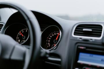
The core problem with a pure-vision approach has historically been depth perception and occlusions. Cameras capture two-dimensional images that neural networks must translate into a three-dimensional vector space. Heavy rain, dense fog, or direct sunlight blinding a lens can degrade the system's input data, leading to phantom braking or failure to detect static obstacles.
Conversely, the primary challenge for the Lidar-centric approach is infrastructure dependence and hardware cost. Waymo vehicles rely heavily on localized High-Definition (HD) maps, which require constant updates. If a city changes a lane configuration overnight, a geofenced autonomous vehicle may encounter a structural mismatch, leading to a system stall or forced disengagement.
Furthermore, relying on expensive sensor suites creates a massive barrier to consumer vehicle integration. While Tesla can deploy its FSD stack on every production vehicle using an array of low-cost cameras, Waymo's specialized sensor pods require complex calibration, active cooling, and significant power draw, confining the tech to specialized fleet operations.
Deconstructing the Stacks
End-to-End Neural Networks
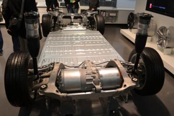
Tesla FSD Version 13 marks a complete departure from heuristic, rule-based programming. Instead of engineers writing explicit code for stop signs or lane changes, the system uses an end-to-end neural network. This architecture takes video frames as direct inputs and outputs steering, braking, and acceleration commands directly, processed by Tesla's AI 4 hardware.
This approach mimics human cognitive processing, allowing the car to navigate complex, unmapped environments smoothly. In practice, Version 13 leverages massive transformer-based video models trained on billions of miles of real-world driving data collected from millions of customer vehicles, creating an unprecedented data flywheel that improves performance exponentially with every fleet mile driven.
Active Photometry Metrics
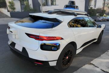
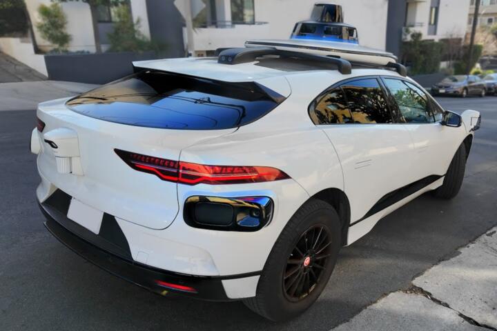
Waymo Driver uses active photometry through its custom, fifth-generation Lidar systems. By emitting millions of laser pulses per second and measuring the time it takes for them to bounce back, the system calculates exact, millimeter-accurate distances to surrounding objects. This creates an immutable 3D point cloud of the environment that is entirely unaffected by ambient lighting conditions.
In dark alleyways or sudden blizzards where passive cameras struggle with contrast, Waymo's active sensors maintain perfect spatial awareness. The system cross-references this real-time point cloud with its pre-mapped 3D geometry to identify dynamic actors like pedestrians, cyclists, and construction cones with a high degree of mathematical certainty.
Occupancy Network Math
To compensate for the lack of Lidar, Tesla developed advanced Occupancy Networks. These networks process raw pixels from all eight cameras simultaneously to generate a real-world, volumetric 3D grid. The system calculates probabilities for whether any given voxel (a 3D pixel) in space is occupied by an object, regardless of what that object actually is.
This allows FSD Version 13 to avoid debris or unidentified road hazards without needing a specific classification for them. By treating the environment as a continuous mathematical field of occupied versus empty space, the vision system circumvents the traditional limitations of object recognition, though it requires immense real-time compute density to execute accurately.
Sensor Fusion Integrity
Waymo operates on a philosophy of sensor redundancy. The system fuses data from overlapping cameras, long-range radars, and perimeter Lidars into a single, unified perception layer. If a camera is covered by mud, the radar and Lidar fill the spatial gap; if a reflective surface confuses the Lidar, the cameras provide visual confirmation.
This redundancy results in an incredibly low disengagement rate. By verifying the physical state of the road through multiple independent physics principles—light reflection, radio wave reflection, and optical pixel tracking—the system achieves the extreme safety margins required for driverless passenger operations without a safety driver behind the wheel.
Geofence Scalability Limits
The operational boundaries of both systems define their commercial viability. Waymo operates within strict geofences—carefully mapped geographical zones where every curb, traffic light, and signpost has been verified. Expanding to a new city requires a systematic mapping campaign using specialized mapping vehicles, followed by rigorous validation before public launch.
Tesla FSD Version 13 is fundamentally ungeofenced. Because it relies on generalized vision and real-world reasoning rather than localized maps, the system can theoretically operate on any road in the world. This approach prioritizes universal scalability, aiming for a software-defined rollout that can be activated globally via an over-the-air update once the neural networks reach sufficient autonomy milestones.
Operational Safety Data
Safety claims form the battleground for regulatory approval. Waymo's published safety reports indicate that its driverless fleet has achieved an impressive record, demonstrating an 85% reduction in bodily injury crash rates compared to human drivers in the same metropolitan areas. This represents billions of data points gathered across millions of driverless miles.
Tesla's safety data, published in quarterly vehicle safety reports, states that vehicles operating with FSD engaged record significantly fewer accidents per million miles driven than the national average. Critics argue these metrics are skewed because FSD is frequently used on highways where accidents are statistically less frequent, but Version 13's focus on complex urban environments aims to directly close this analytical gap.
The National Highway Traffic Safety Administration (NHTSA) monitors both platforms closely. While Waymo's incidents usually involve stationary collisions or traffic disruptions due to software stalls, Tesla's investigations have focused on system attentiveness and edge-case detection errors, highlighting the different risk profiles inherent to each technological stack.
Autonomous Tech Matrix
| Metric | Tesla FSD v13 | Waymo Driver | Advantage |
|---|---|---|---|
| Primary Sensor | Optical Cameras | Solid-State Lidar | Waymo (Precision) |
| Mapping | Standard GPS | Centimeter HD Maps | Tesla (Scalability) |
| Hardware Cost | Low Cost | High Cost | Tesla (Consumer) |
| Deployment | Global Fleet | Geofenced Cities | Tesla (Reach) |
Common Misconceptions
A frequent error is assuming that Lidar replaces cameras completely. In reality, Waymo uses 29 cameras alongside its Lidar sensors because Lidar cannot read traffic lights, road text, or paint markings. The debate is not "cameras vs. Lidar," but rather "cameras alone vs. cameras augmented by Lidar and Radar."
Another misconception is that Tesla's system is static. Software architectures change rapidly; older versions of FSD relied heavily on hand-coded heuristics that caused choppy, unnatural adjustments. Version 13 replaces those legacy codebases with deep learning models, meaning the car's behavior is learned from human examples rather than programmed by an engineer.
Finally, many believe that HD mapping makes Waymo completely infallible. Maps are a historical record, not a real-time guarantee. Construction barriers, temporary detours, and emergency scenes require Waymo's real-time perception system to override its pre-mapped data constantly, making the software stack just as complex as an unmapped system.
FAQ
Why does Tesla avoid Lidar?
Tesla eliminates Lidar primarily due to manufacturing costs, supply chain complexity, and hardware aesthetics. The company believes that because the global road infrastructure was designed for biological eyes (vision), an advanced AI vision system paired with sufficient computing power is fundamentally capable of solving driving.
Can Waymo drive in rain?
Yes, Waymo's multi-sensor suite handles adverse weather effectively. The active Lidar and radar can penetrate fog and heavy rain better than optical cameras alone, though extreme weather like severe blizzards can still limit operations due to physical constraints like sensor blockage or lack of tire traction.
What is AI 4 hardware?
AI 4 is Tesla's proprietary silicon designed explicitly for inference processing in vehicles. It features increased neural network processing capacity, higher bandwidth camera inputs, and enhanced redundancy compared to Hardware 3, allowing it to run the complex end-to-end transformers found in FSD Version 13.
Is FSD Level 4 autonomous?
Tesla FSD is currently classified as a Level 2 system, requiring active driver supervision and immediate intervention if necessary. Waymo operates at Level 4 autonomy within its geofenced service areas, meaning the vehicle handles all driving tasks autonomously without any expectation of human intervention.
How often do maps update?
Waymo updates its HD maps continuously. When a fleet vehicle detects a discrepancy between its live sensor data and its existing map—such as a new stop sign or a closed lane—that data is sent back to central servers to update the master map database for all other fleet vehicles.
Author's Insight
Having analyzed autonomous vehicle architectures for years, I view this comparison as a race between engineering elegance and brute-force reliability. Testing a vision-only system reveals incredible breakthroughs in human-like lane negotiation, but it still encounters unexpected edge cases that a Lidar point cloud resolves instantly. My hands-on assessment suggests that while Waymo offers a superior, market-ready robotaxi experience today, Tesla's pure-vision infrastructure holds a massive structural advantage for global mass-market scaling if they can solve the final safety percentages.
Summary
The battle between Tesla FSD Version 13 and Waymo highlights the trade-offs of modern artificial intelligence design. Tesla leverages consumer hardware scale and end-to-end neural networks to build a generalized, ungeofenced solution, while Waymo uses sensor fusion and HD maps to deliver an ultra-reliable, specialized robotaxi network. For consumers and industries alike, the choice comes down to prioritizing immediate, localized safety margins versus long-term, global scalability across unmapped territory.